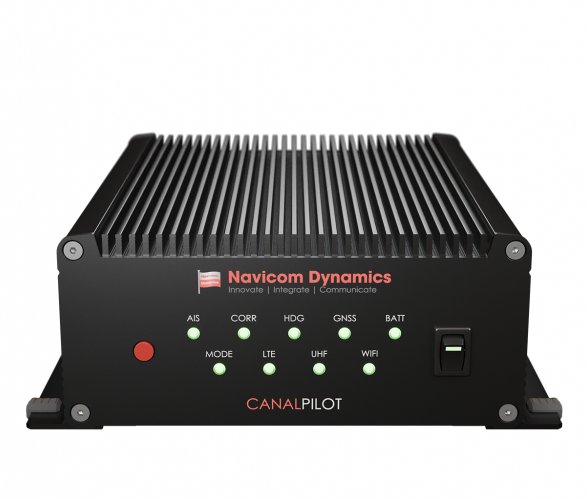


CanalPilot
Navicom Dynamics’ Precision Navigation system, the CanalPilot, is the ultimate tool for total situational awareness to ensure safe navigation of vessels through the Panama Canal.
We're proud to announce the CanalPilot has completed and passed all required testing with the Panama Canal Authority (ACP). The CanalPilot is an approved non-portable pilotage unit for Neo-Panamax vessels transiting the Panama Canal.
CanalPilot receives accurate and real-time vessel dynamics information on any number of screens to equip the vessels’ navigational crew and key personnel and synchronise operations and communication.
CanalPilot is user-friendly and becomes a familiar secondary source of reliable and accurate information which is independent of the ships’ navigational systems.
It is a non-portable pilotage system and fully compliant with the Panama Canal Authority's requirements as set out in their Advisory To Shipping No. A-32-2022.
With the CanalPilot, you can:
- Facilitate critical decision making during ship-handling and improve safety of crucial manoeuvres
- Easily add-on shore based data from a server to enhance the information modules to include weather, tides, DUKC and other critical data to support navigation.
- Use it as a fall back navigational system that can optionally include battery back-up to provide a totally independent navigational tool in case all else fails.
Contact our Sales Team today to discuss how we can assist your ship to be compliant with the ACP's regulations for non-portable pilotage systems.
View the Panama Canal Authority's approved pilotage list here:
https://pancanal.com/en/maritime-services/non-portable-piloting-unit/
Features
Performance Features & Usability
Independent of vessel: The system is entirely independent of the vessel. It is a secondary source of vital vessel information that supports critical decision-making during manoeuvres.
Critical information source/data points: Get accurate Position, Heading, Rate-of-turn, COG, SOG and other useful data to create a stable image of the vessel on the chart display software with optional future vessel path predictions.
Situational awareness: Increased situational awareness of the vessel and its surroundings made available on as many displays as required (to equip entire crew).
Portability: Information available on portable displays (tablets/iPads), allows the crew to easily walk around the bridge wing or any location that has been set up.
Extendibility: Add-on any number of screens to interface with CanalPilot to provide the same accurate & real-time information to additional crew members for a synchronised operation. Add-on shore based data points from a server to the software to appear as integrated information to the user (with the original data points from the PPU).
Premium Quality: High quality sensors with advanced technology to form state-of-the-art systems that are accurate, reliable and user-friendly.
User-oriented, feature-rich software: A number of useful features to improve training, usability, safety and for personal enhancement.
Specifications
Physical Specifications
- Dimensions: 186 x 81 x 250mm (WxHxD)
- Weight: 3.5 kg
- Power requirements: 90-240 VAC 1A / 24 VDC 1A
- Battery Back-up: > 8 hours of operation
- Indicators: Diff lock, Diff RX, Heading, GNSS, Power, WiFi, AIS, UHF, Battery
Technical Specifications
GNSS
- Position source (Frequencies): L1C/A, L2C, L1OF, L2OF, E1, E1B/C, E5b, B1l, B2l
- Tracked systems: GPS, QZSS, Galileo, GLONASS, BeiDou
- Correction source: RTCMv3 (NTRIP/UHF), SBAS
- Position accuracy: RTK: 0.01m +/s 1ppm CEP, SBAS: 1m
- Heading: HDG Accuracy: < 0.02° (10m baseline)
- Rate of Turn: ROT Accuracy: < 0.1°/min
RTK/DGNSS Corrections
- Network corrections: NTRIP (via WiFi)
- UHF corrections: Using RTCMv3 over UHF connection
IMU (Inertial Measurement Unit)
- IMU Gyro Bias Instability: < 1°/hr (0.4-0.7°/hr typ.)
- IMU Angular Random Walk: ≤ 0.08°/√hr
UHF Radio
- Pre-tuned to 454.325 MHz using TrimTalk 450S to receive RTCMv3 DGNSS corrections
- Frequency range: 410 – 480 MHz
- Occupied bandwidth: 6.25, 12.5, 25 kHz
- Modulation type / Protocol: GMSK, Trimtalk 450S (+ others on request)
- Receiver Sensitivity: < -115dBm
AIS Receiver
- Dual frequency: 161.975 & 162.025 MHz
- Receiver Sensitivity: < -107dBm at 20% packet error rate
Wi-Fi
- Access Point: IEEE 802.11 a/b/g/n
- Number of clients: 10
- Security: WPA2
- Output power: 18 EIRP [dBm]
- Receiver Sensitivity: < -82dBm
Data / Connectivity
- Data output (NMEA/AIS): GGA, VTG, HDT, ROT, GSA, GSV, VDM
- Data protocol: NMEA-0183 (compatible with Trelleborg SafePilot)
- Connectivity: Wi-Fi, Ethernet (optional)
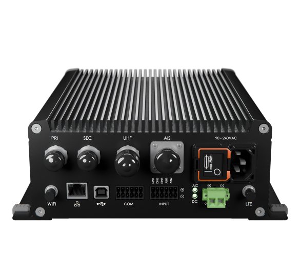
External Interfaces
- GNSS Antennas x2: TNC Jack
- UHF Antenna: N Jack
- VHF Antenna: SO239 Jack (mates to PL259)
- Wi-Fi Antenna: RP-SMA Jack
- USB (device only): USB Type B
- Mains power: 3-pin IEC C14 Inlet
- DC power: 2-pin Terminal Block w Screw Lock
Environmental Specifications
- Operating Temperature: -20°C to +74°C (-4°F to +165°F)
- Storage Temperature: -40°C to +85°C (-40°F to +185°F)
- Humidity: 95% (non-condensing)
- RoHs: CanalPilot meets the directive for Restriction of Hazardous substances
Technical Docs
Product Enquiry
Related Products